")
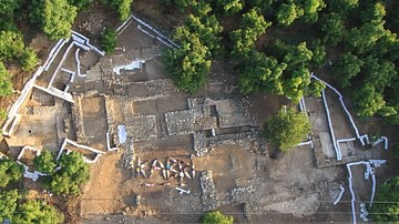
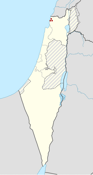
Tel Kabri is an archaeological site in the Western Galilee in northwestern Israel and the location of one of the largest palaces in Canaan in the Middle Bronze Age or "MB" (c. 2,000–1,500 BCE), the period in which Tel Kabri was at the height of its power. The palace belonged to a political entity that is as yet unnamed and is largely unknown.
Geography & Excavations
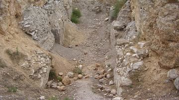
Like many Ancient Near Eastern archaeological sites, much of the Kabri site is located on a tell. A "tell" is a manmade mound composed of layers or strata, each representing the remains of a period of occupation, deposited one on top of the other as settlements rose and fell, and compressed by the weight of centuries, with the most recent layers on top. The strata at Kabri date from the Neolithic period (the deepest strata) to modern times (the strata nearest the surface). It is a relatively low mound extending over a wide area and covered today by avocado groves tended by the local kibbutz, Kibbutz Kabri.
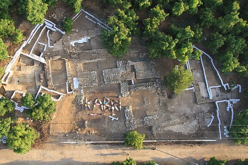
The site has been excavated by archaeologists from time to time since 1956 CE. There were two surveys, five minor excavations, and two major excavations. The first major excavation was conducted from 1986–1993 CE by Aharon Kempinski whose expedition found many of the structures comprising the Middle Bronze Age palace, as well as floor and wall frescoes reflecting the style of far-off Aegean cultures, all as described below.
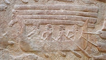
The second major excavation began in 2005 CE when Professors Assaf Yasur-Landau of the University of Haifa and Eric H. Cline of The George Washington University reopened excavations of the site, with Professor Andrew Koh of Brandeis becoming Associate Director of the expedition in 2013 CE. The ongoing excavations have provided archaeological evidence of the development of the palace described below and studied the Canaanite society and economy of Kabri and surrounding areas and their relationship to the wider Mediterranean world, particularly the Aegean. The current expedition has found additional Aegean-style wall and floor frescoes, and, in the 2013 and 2015 CE seasons, the expedition uncovered large storage areas and many ceramic storage vessels which represent the oldest wine cellar in the world and the largest in the Ancient Near East.
EarlY History
Although Kabri saw its heyday in the Middle Bronze Age, the area was inhabited as far back as the Pottery Neolithic period (c. 6,400–4,500 BCE) and the early part of the Chalcolithic period, or Copper Age (c. 4500–3500 BCE). The inhabitants were drawn to Kabri by the waters of its springs, but the Kabri settlements mysteriously disappeared in the later part of the Copper Age.
However, in the Early Bronze Age ("EB"), which began around 3500 BCE, a Canaanite town sprang up on the site of Tel Kabri which likely covered the northern half of the tell. (In ancient times, the region that includes modern Israel and surrounding areas was inhabited by a people called "Canaanites" until they were displaced by Israelites sometime in the Iron Age, under circumstances that are much debated, and their land was called Canaan.) This town disappeared - along with countless others throughout the eastern Mediterranean - around the end of the EB in about 2100 BCE, in a mysterious, unidentified wave of destructive events generally known today as the "Early Bronze Age Collapse."
The Middle Bronze Age
The Pre-Palatial Period
The site remained uninhabited until early in the first part of the Middle Bronze Age, which is known as "Middle Bronze Age I" or "MB I" (c. 2000–1720 BCE). In the early and middle parts of MBI, Tel Kabri was inhabited once more, as shown by the appearance of new tombs and private houses at the site. During much of MB I, the Kabri settlement appears to have been unfortified.
The Four Palaces
The First Palace. Sometime in the middle to late MB I, Kabri's "first palace" and fortifications were constructed. Construction of the first palace began after residential structures built in MB I were razed and the land was flattened out and covered with a layer of earth and debris. The main structures were two thick parallel stone walls, which the Kabri archaeologists called the "corridor," and a room to its north with a plaster floor. The first palace may have resembled a fortress more than a grand palace (Yasur-Landau et al. 2014, 357).
The Second Palace. Then, at about the time of the transition from MBI to the next period, Middle Bronze Age II or "MB II" (a period which lasted from about 1720 BCE to 1550 or 1500 BCE), Kabri's palace grew larger, becoming what we will call the "second palace." The larger second palace replaced the fortress-like first palace, and the corridor and northern room were filled in. Three rooms were built to the east of the corridor area, and one or possibly two meeting halls were built to the west. A thick barrier of earth was built around the site, helping the rulers secure their authority and likely giving Kabrians a greater sense of safety.
It is believed that around this time, Kabri and the coastal city of Acre were in contention for control of the Western Galilee. This may have been reflected in the construction of the fortress-like first Kabri palace and the great earth wall around the second palace, as well as in the abandonment of smaller sites loyal to Kabri as people moved to Kabri and in the fortification of some of Kabri's outposts - such as nearby Achziv.
The Third Palace. Later on, in the MB II period, the palace was greatly expanded again - to the northeast and south, to create the "third palace." This was a time when Kabri apparently won out over Acre for control of the Western Galilee, and this may be reflected in a change in the focus of the palace. In the new third palace, the emphasis seems to have shifted away from defense and military might to displays of culture and wealth. The third palace incorporated many advanced architectural elements, and was decorated with wall frescoes and floor paintings incorporating Aegean art styles and themes. These changes may have represented an attempt to make Kabri appear to be a player on the international stage.
The Fourth Palace. One final expansion resulted in the "fourth" - and final - palace at Kabri. The fourth palace included a separate two-room building in which plaster-covered stone slabs from the beach called "orthostats" lined the foundations, and the building was called the "Orthostat Building" by the Kabri archaeologists. Most importantly, the fourth palace included the Southern Storage Complex, and, as we have said, perhaps many more rooms to the north and west of the Southern Complex and beneath the roadway. The storage rooms that may lie beneath the Southern Complex probably belong to the third palace.
The fourth palace was larger than any of the previous three, but was not as artistically decorated as the third palace. In fact, the frescoes and other plaster paintings of the third palace appear to have been destroyed. Their fragments were used not as decoration, but as packing material, with the painted sides turned face down to conceal their colours so that they could be used as filler in in with white or plain floors and walls of the fourth palace. It is believed that this change was not the result of Kabri losing contact with the Aegean but more likely the result of a shift in the focus of the Kabrians' international communications to Cyprus at this time. The fourth palace appears to have been expanding in size right up to about 1550 BCE.
Destruction of the Palace. However, in the late MBII, around 1550 BCE, or perhaps even earlier, the palace was destroyed, and the entire site was abandoned. The reasons for this and the precise date are unknown, but the Kabri archaeologists have suggested that the storage rooms may yield clues (Yasur-Landau et al. 2014, 364).
After the Middle Bronze Age
Following the destruction of the MB palace, there is little evidence that the site was occupied again until the 8th century BCE, during the Iron Age. At that time, Phoenicians established a town called Rehov and a garrison of Greek mercenaries at the site, and the Phoenician city-state of Tyre ruled Kabri. However, in 585 BCE, the Neo-Babylonian armies of King Nebuchadnezzar destroyed the town and citadel of Kabri, and many other sites in the Levant, and eventually captured Tyre itself 12 years later.
In 538 BCE, the Persian armies of Cyrus the Great swept through the region, and a small village appeared on Tel Kabri which lasted until 332 BCE, in the time of Alexander the Great. In the Hellenistic period after 332 BCE, Tel Kabri itself was largely deserted. The only known organised human activities in this period were local burials in the old Phoenician citadel, but no one appears to have lived at Tel Kabri. Starting in the Roman Period, an area to the east of the tell took a name derived from Kabri for the first time - Kabrita was its name - and thereafter this area became the preferred place for occupation up to the foundation of the modern State of Israel.
Modern History
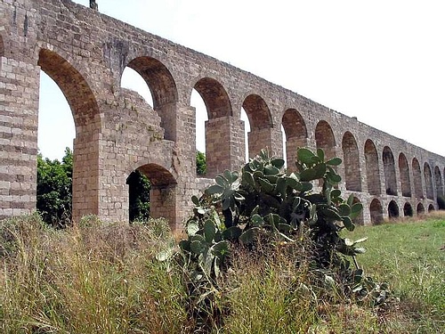
In the Ottoman period (c. 1517–1917 CE), the Arab village of el-Qahweh (later called en-Nahr), and the later offshoot village of et-Tell, were founded at Tel Kabri, where the inhabitants operated farms and a mill, respectively. Also in this period, a major aqueduct was constructed from Kabri to Acre.
The Ottomans were defeated in World War I, and in the British Mandate Period (1920–1948 CE), which began after the War, the tell remained relatively unchanged. The only addition was a road running through it from the coastal city of Nahariyyah to a nearby Jewish village.
In Israel's War of Independence in the late 1940s CE, the Arab villages on Tel Kabri and the village of Kabri to the east were forcibly emptied, and in 1948 CE, the site became part of the current Kibbutz Kabri. In 1956, the first archaeological remains of the Neolithic inhabitants were identified and the story of Tel Kabri as an archaeological site began.