Although mentioned several times in the Biblical texts, the actual existence of the Hittites was largely forgotten until the late 19th century CE. With the discovery of Hattusa in 1834 CE, the city that was for many years the capital of the Hittite Empire, the Hittites were finally recognized as one of the great superpowers of the ancient Middle East in the Late Bronze Age (1550 - 1200 BCE).
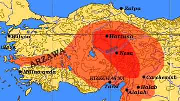
The Hittites populated the broad lands of Anatolia (modern-day Turkey) originally occupied by the Hatti and later expanded their territories into northern Syria and as far south as Lebanon. The Hittite language, which was written in both cuneiform script and hieroglyphics, is believed to be the oldest of the Indo-European languages and was deciphered only in 1915 CE. Religion played an important role in Hittite life. The Hittites worshipped so many deities that they referred to them as “the thousand gods of Hatti”. At the centre of the Hittite pantheon were the storm god Teshub and his wife the sun goddess Hebat.
The Hittite kingdom reached its greatest extent during the mid-14th century BCE under Suppiluliuma I (c. 1344 - 1322 BCE) and his son Mursili II (c. 1321 - 1295 BCE). The collapse of the kingdom around 1200 BCE drove the Hittites south where they created a series of Neo-Hittite city-states north and east of Adana (modern-day southern Turkey). Some of these lived on into the 8th century BCE before vanishing from the pages of history.
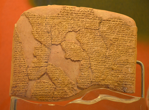
The rediscovery of the Hittites was one of the major archaeological achievements of the last century, and Hattusa, their capital, has since been declared a World Heritage site by UNESCO. An enlarged copy of a cuneiform clay tablet found at Hattusa hangs in the United Nations building in New York. This tablet is a peace treaty signed between the Hittite Empire and Egypt in 1258 BCE after the famous Battle of Kadesh. The Treaty of Kadesh holds the distinction as the world's first peace treaty whose text is known to have survived.
Reamasesa-Mai-amana, the great king, the king of the country of Egypt, shall never attack the country of Hatti to take possession of a part (of this country). And Hattusili, the great king, the king of the country of Hatti, shall never attack the country of Egypt to take possession of a part (of that country).
The most impressive Hittite remains are scattered between Çorum, north-east of Ankara, and Kayseri on the eastern fringes of Cappadocia. On my last trip to Turkey, I ventured off the beaten track to discover the land of the Hittites and explored their cities, citadels and religious centres. I have compiled a list of the five most important Hittite settlements.
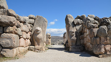
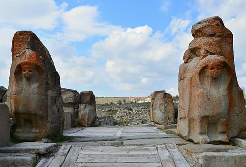
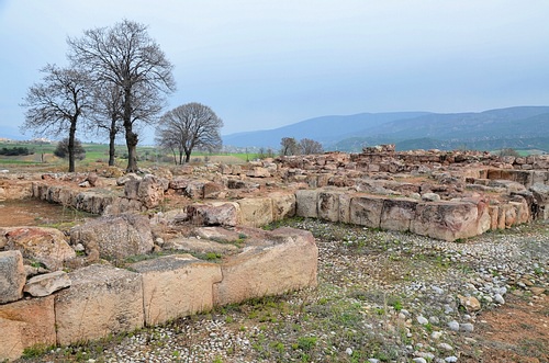
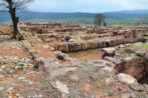
Hattusa
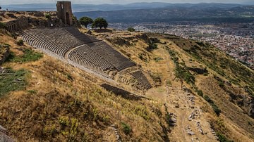
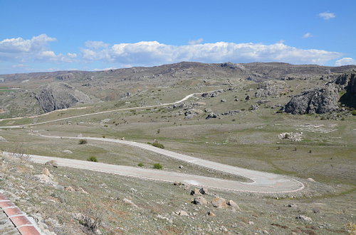
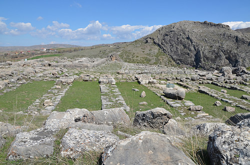
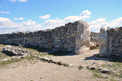
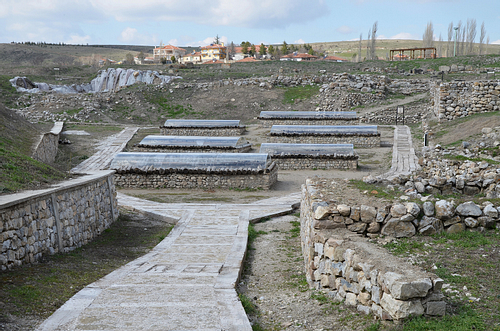
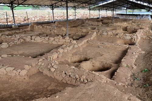
Hattusa was the capital city of the Hittite Empire. It is located in the Boğazkale District of the Çorum Province, 150 kilometres (93 miles) east of Ankara. The ruins of the city walls, the gates, the temples and the palaces awaiting the visitors today provide a comprehensive picture of the Hittite capital in the 13th century BCE.
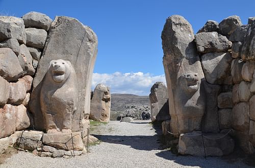
The site was discovered on July 28 in 1834 CE by Charles Texier, but the first systematic excavations in Hattusa began in 1893-1894 CE under the guidance of Ernest Chantre who published the first cuneiform tablets from Hattusa. Since 1907 CE archaeological work has been carried out by the German Archaeological Institute. The city consisted of two separated districts: the Lower City—the district of the Old City of the Hittites where the main temple was located, and the Upper City - a newer part of the city with a fortified palace complex surrounded by massive walls. The site also boasts a number of hieroglyphic inscriptions bearing traces of the so-called “Luwian” script.
The earliest traces of settlement on the site are from the 6th millennium BCE. During the 19th and 18th centuries BCE, the Hattians and the Assyrian Trade Colonies settled in the area. Hattusa, named Huttush at the time, was one of the karu (trading post) established by the merchant colonies of Assyria. Hattush came to an end around 1720 BCE when Anitta, king of Kussara (of the dynasty that would form the Old Hittite Kingdom), sacked the city. A generation later, another king of Kussara decided to make the city his capital. A new town was planned and built on the ruins of the old one, and the Hittite language was introduced to the region. Hattush became the Hittite city of Hattusa, and the king took the name of Hattusili I, the “one from Hattusa”. Over the next few hundred years, Hattusa remained the capital of the Hittite empire.
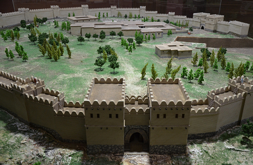
At its peak, the population of Hattusa reached an estimated 40,000 - 50,000 inhabitants. The city was vast, covering 1.8 km² (0.7 mi²) with massive defensive walls over 6 km (4 miles) in length and huge watchtowers and secret tunnels. Upon entering the site, the first thing the visitor sees is an evocative reconstruction of a 65 m (123 feet) long section of the city's fortifications. The original wall was made of mud brick with defence towers built at intervals of 20 - 25 m (65-82 feet). The reconstructed part rests on top of the original Hittite foundations. The inner city wall shielded the area of the Great Temple and adjacent settlement.
The whole tour of the ancient city can be completed following the main sightseeing circular route of 3 - 4 km (2 - 3 miles) either on foot or by car. The site is divided by the Kızlarkayası creek into the lower city in the north and the upper city in the south with multiple stopovers along the way. In order to experience Hattusa thoroughly, travellers are advised to tour the city on foot. However, the full circuit around the site is a long walk with challenging climbs uphill, taking at least three hours.
The city was destroyed, together with the Hittite state itself, around 1200 BCE, as part of the collapse of the Late Bronze Age kingdoms. Excavations at the site revealed that Hattusa was invaded and burned to the ground early in the 12th century BCE after many of Hattusa's residents had abandoned the city. The site was subsequently abandoned until 800 BCE when a modest Phrygian settlement appeared in the area.
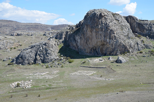
Yazilikaya
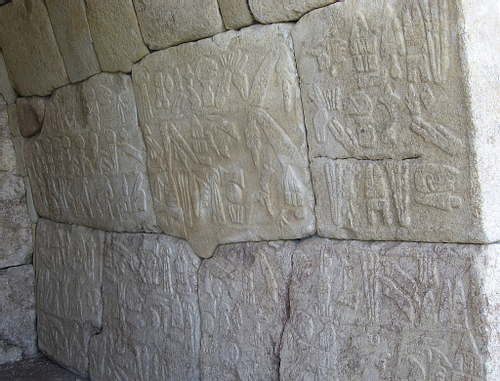
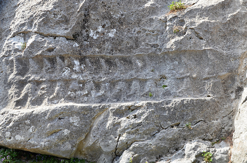
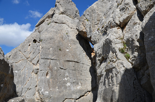
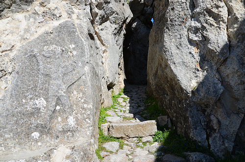
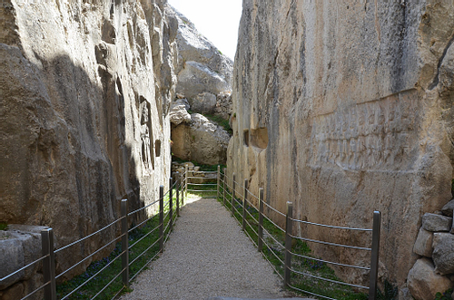
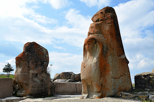
Yazılıkaya (“Inscribed Rock”) is a Hittite rock sanctuary located about 1.5 kilometres (1 mile) northeast of Hattusa. It is the largest known Hittite rock monument. The sanctuary consisted of a temple-like building, and two open-air chambers cut into the bedrock.
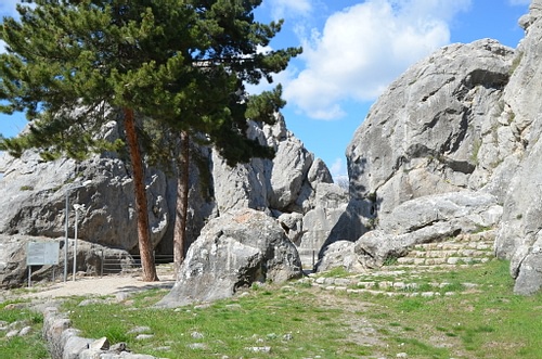
The Yazılıkaya sanctuary served as a place for the celebration of the arrival of the New Year each spring. These ceremonies took place in the open air in front of the Hittite Pantheon. The sanctuary was made of two rock chambers, later labelled Chamber A and Chamber B by archaeologists. The walls of each chamber were covered with the richest and most beautiful samples of Hittite relief art. They featured gods and goddesses and the figures of the Great King Tudhaliya IV (c. 1237 – 1209 BCE). There are a total of 83 images, 66 in the Chamber A and 17 in Chamber B.
Human activity on the site probably began in the 16th century BCE, although what we see today is probably the result of modifications made in the late 13th century BCE, not long before the Hittite Empire began its steep and mysterious decline.
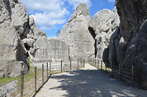
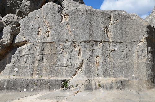
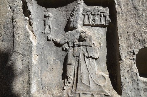
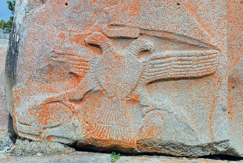
Chamber B is accessible via a narrow passage with winged demons on both sides. It is believed that Chamber B was built as a memorial chapel for Tudhaliya IV, dedicated by his son Suppiluliuma II at the end of the 13th century BCE. The reliefs on the walls are much better preserved than those in Chamber A. A line of gods of the underworld is pictured on the wall immediately to the right of the entrance. On the opposite wall is a representation of Nergal, the God of the Sword and the Underworld. To the left of this relief, a cartouche with the name of Tudhaliya IV is visible, and this same king is depicted being embraced by the god Sharruma (son of the Thunder God Teshub).
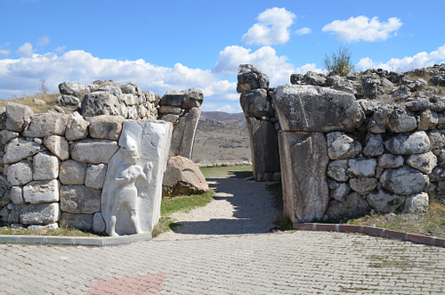
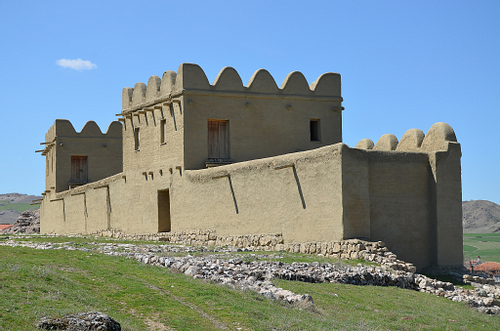
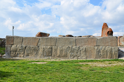
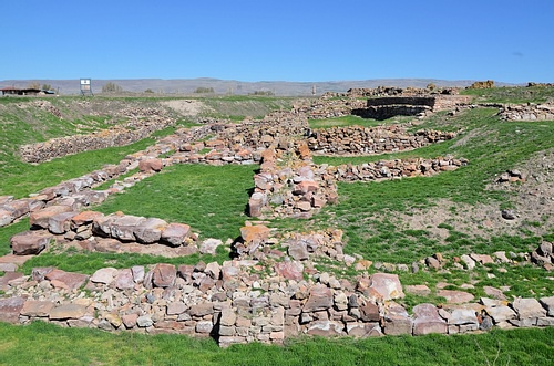
Alacahöyük
Alacahöyük was the centre of the flourishing Hattian culture during the Bronze Age. It was later occupied by the Hittites who used the city as their first capital before moving over to Hattusa. The site is located in Alaca, northeast of Hattusa.
Alacahöyük was discovered in 1835 CE by the English archaeologist W.G. Hamilton. The first excavations started in 1861 by French archaeologist George Perrot, but more extensive work was initiated by the Turkish Historical Association in 1935 and continued until 1948. Since 1997, the excavations have been carried out by Ankara University under the direction of Prof. Dr. Aykut Çınaroğlu.
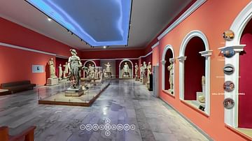
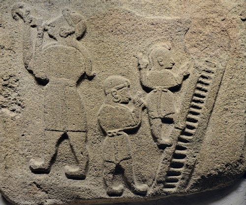
The excavations revealed 15 layers of settlement buried under the soil dating back to 5500 BCE - 600 BCE. The richest and most important layer belongs to the Early Bronze Age. Many treasures have been excavated from the 13 Hattian royal tombs dating to the 3rd millennium BCE. Among these artefacts were bronze sculptures of bulls or deer, ceremonial symbols and sun disks. These artefacts are housed today in the Museum of Anatolian Civilizations in Ankara.
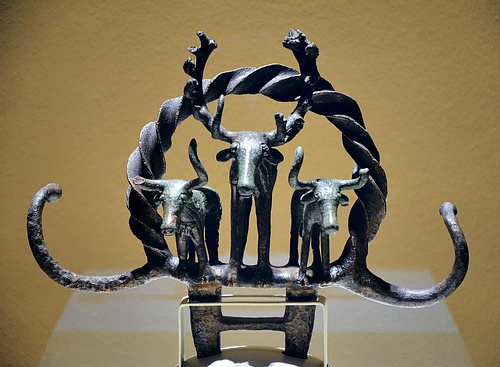
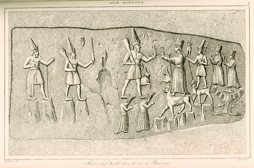
The lower parts of the towers were decorated with orthostat reliefs depicting a religious ceremony including a king and a queen praying to a bull before an altar, a lion hunt, animals being sacrificed as well as jugglers and acrobats. These depictions represented an entire ritual set of cult, libation, hunting and entertainment that included a religious ceremony in honour of the storm god. The original reliefs are on display in the Museum of Anatolian Civilizations in Ankara.

Kültepe
Kültepe, located 18 kilometres (11 miles) northeast of Kayseri and formerly known as Kanesh and Karum, was part of the network of trading settlements established in central Anatolia by Assyrian merchants from Ashur (northern Mesopotamia) in the early 2nd millennium BCE. This period was called the “Assyrian Trading Colonies Period“. During this time, the Assyrians were very active in international trading. Assyrian merchants sold tin and textile products in exchange for precious metal like gold, silver and copper. Later on, the Hittites inhabited the city which they called Neša and made it their first capital. The site is composed of two parts, the lower town Karum and the upper mound Kanesh.
Anatolia entered recorded history in Kültepe as it is the site of the discovery of the earliest written documents in Turkey. Assyrian merchants documented and recorded their transactions on clay tablets in the ancient Assyrian dialect using the cuneiform script. Thousands of these texts stored in household archives were preserved when fire destroyed the city in c. 1836 BCE. Today, the clay tablets found at Kültepe provide a glimpse into the complex and sophisticated economic, political and social interactions that took place during the beginning of the 2nd millennium BCE.
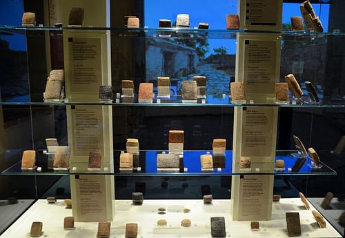
These clay tablets also provide valuable information about the early Hittites. Among the local rulers who settled in Kanesh was Anitta, the earliest known ruler to compose a text in the Hittite language (and the oldest known Indo-European text).
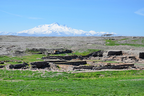
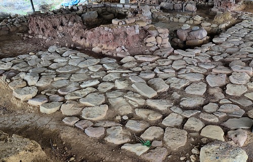
Sapinuwa
Located in Ortakoy, 53 kilometres (33 miles) southeast of Çorum, Sapinuwa was an important Hittite military and religious centre. The city was established in a long valley between Alacahoyuk and Hattusa, along the east-west trade route leading to Middle Anatolia. Sapinuwa was also the residence of several Hittite kings and for some time the capital city of the Empire.
Sapinuwa was mentioned on cuneiform tablets unearthed during excavations at Hattusa, but its location was not identified until 1989 CE when a farmer found clay tablets while ploughing his field. The excavations at the site began the following year in 1990 on behalf of Ankara University. The site has yielded an archive of about 4,000 tablets and tablet fragments dating back to the beginning of the 14th century BCE.
The ruins of Sapinuwa are spread out over 9 km² (6 mi²) and include many building foundations. A monumental structure with cyclopean-walls, the so-called “Building A”, was uncovered at the site. It was a three-story building used for administrative, religious and commercial purposes. The other structures discovered include a warehouse for large jars where grain, wine and olive oil were stored. A street that lies in a north-south direction with workshops on one side was also unearthed. Some of the Sapinuwa finds are on display in the Museum of Çorum.
In recent years, awareness and interest in the Hittite world have had a boost. This is reflected in the publishing of numerous books and guides in English and in German and the public success of the Hittite exhibition staged in Germany in 2002 ('Hittites: Nation Of 1000 Gods'). In 2019, the Louvre in Paris will be hosting an exhibition called 'Forgotten Kingdoms From the Hittite Empire to the Arameans' which invites visitors to discover the mythic sites of this forgotten civilization, such as the majestic remains of the Tell Halaf site, located near the current Turco-Syrian border.