")
When it comes to ancient history, Pakistan contains its fair share of treasures, one of the prominent of these being the ancient metropolis of Taxila. It is a city of the Gandharan civilization, sometimes known as one of its capitals, whose history can be traced from early microlithic communities at the Khanpur caves up to almost 1000 CE. Taxila was a hub of Buddhism, a centre of learning, an urban metropolis and a meeting point of various cultures, namely the Achaemenids, Greeks, Mauryans, Scythians, Parthians, Kushans, Huns and eventually the Muslims.
Although it was lost to time for nearly 1000 years following its decline, the metropolis and its multitude of treasures came to light in the late 1800s CE under Alexander Cunningham who was an antiquarian for the British Raj and more prominently under John Marshall, the first director of the Archaeological Survey of India in the early 1900s CE, a time when archaeology worldwide had became a much more disciplined field and new discoveries were coming to light from all over the world. Along with discovering the Indus Valley civilization, Marshall also did major work in Taxila which bring to light this ancient and mysterious culture.
Location
The Taxila archaeological site is located in the province of Punjab, Pakistan, about 30 km north of the Capital Territory of Islamabad. It lies off the famous and historical Grand Trunk Road. The modern archaeological region of Taxila is composed of 18 sites of significant cultural value which were inducted as a whole into the UNESCO world heritage umbrella in 1980 CE.
The region is of particular interest when one looks at its ancient role as being a waypoint for the movement of caravans and even today it still holds the same function as in the 6th century BCE. This continuing function of the site as a waypoint tells us about the urban pattern of ancient Taxila (being more or less unchanged since antiquity) and how that affects development and the spread of crafts, settlements and markets as well as an institutional framework which develops as a result of the need to manage the surrounding population.
Although the region fell out of favor with the increase in sea trade in later times, the preceding centuries of occupation meant that a massive amount of archaeological data still remains in the region which has been slowly and gradually unearthed from the British era down to the present day.
Pre-History of Taxila
The beginnings of human occupation in the area can be traced back to the microlithic hunters of the period before 3500 BCE, most importantly at three important caves discovered in 1964 CE by Elden Johnson of the University of Minnesota at Bhamala, Mohra Moradu and Khanpur. Particularly at the Khanpur cave, 2.9m (9 ft 7 inches) of cultural deposit was found dating from 900 CE all the way back to the stone age.
Early agricultural communities developed around 3500-2700 BCE as is evidenced from the small mound of Saraikala - "small" being relative as it is 305 m (1000 ft) east to west and 610 m (2000 ft) north to south - excavated by Ahmad Hasan Dani, a pioneering archaeologist of Pakistan. This site contains evidence of stone, bone and handmade pottery. The stone objects include microliths, axes and maceheads along with parallel-sided blades, side and end scrapers, and assymetrical flakes and arrowheads. Ground stone tools are also found such as chisels as well as saddle querns, grinders and pounders for daily use. Bone tools belonging to five categories have been found including awls, perforators, spatulas, points and pressure flakes. Pottery is the third industry with the earliest examples being almost all handmade and divided into four subcategories.
The Bronze Age begins in the region around 2700-2100 BCE and is also evidenced at Saraikala with no break between the end of the neolithic to the Bronze age deposits. There is even a transitional period between the two ages which includes mixed implements of neolithic and bronze age varieties.
Takhshashila
According to mythology Taxila is said to have been founded by the son of the brother of the legendary hero Rama, and stood on a hill that commanded the river Tamra Nala, a tributary of the Indus. It is held to have been an important cultural centre since inception, and the Mahabharata was reported to have first been recited here. The site of the first city at Taxila is known now as the Bhir Mound.
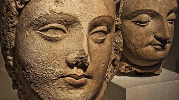
The city of Taxila, known in antiquity as Takhshasila, was a renowned site of Buddhist Gandhara, especially after Ashoka's rule and in the 1st century CE Kushan era. The name Taxila is a Greek approximation of the original name. In Aramaic the city is known as Naggaruda, the 'City of Cut Stones' which is also the Buddhist name for the city, at least if taken literally i.e. taks meanining to cut or fashion something, which implies this name. However, in the same vein sila is also related to "sira" meaning "head" in Buddhist traditions and relates to the story of the Boddhisattva who voluntary had himself beheaded in sacrifice to a local Brahman in the city of Bhadrasila which the Buddha, while relating this story, is said to have linked to Taxila. The city of Sirkap also has a similar meaning i.e. sir or head and kap, to cut but this has not been proven satisfactorily yet.
Chu-cha-shi-lo is the Chinese name given to the region found in the accounts of the Chinese pilgrims. In Sanskrit, it is known as Takshasila, Takkasila or Takhashila and was also said to be the land of the Takhshas-a serpent race who could change their form at will to mingle with humans. Another Brahmanical tradition relates that it was the capital city of Taksha, son of Bharata, who was installed here as king.
The ancient city was revered as having one of the world's first universities and flourished during the 1st to 5th centuries CE as part of the civilization of Gandhara under various rulers. A variety of subjects were taught there, including mathematics, sciences, philosophy, astronomy, medicine, politics, literature and military sciences although it was not an institutionalised center of learning but rather a combination of religious plus secular studies centered around monasteries.
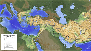
Situated on "The Royal Highway" (as termed by the Greek Megasthenes) It was connected to Pataliputra (modern day Patna) in the north eastern reaches of the Mauryan Empire, western Asia (through Bactria), across the Indus River at Hund and through Kashmir with Central Asia by way of Srinagar, leading down to Haripur. This allowed a steady influx of people from all over the Asiatic regions into the area in the form of traders, settlers, merchants, preachers and invaders.
Political control
Taxila and the region of Gandhara witnessed the rule of several major powers of antiquity as listed here:
- Achaemenids (~600-400 BCE)
- Greeks (~326-324 BCE),
- Mauryans (~324-185 BCE),
- Indo-Greeks (~250-190 BCE),
- Scythians (~2nd century to 1st century BCE),
- Parthians (~1st century BC to 1st century CE),
- Kushans (~1st to 5th century CE),
- White Huns (~5th century CE)
- Hindu Shahi (~9th to 10th century CE).
This was followed by Muslim conquests by which time we come to the medieval period of Indian history.
The Achaemenian rule in Gandhara lasted from the 6th Cent BCE to 327 BCE, when Alexander of Macedon invaded the region. However he wasn't able to hold it for too long and his armies turned back towards their homes soon after and following this void, Chandragupta Maurya reconquered the region and began the Mauryan dynasty in c.321 BCE, the first unifying dynasty of India. This dynasty collapsed after the demise of its greatest ruler, Asoka (c.273-232 BCE).
The region hence fell into another vaccum which was filled by the so called Indo or Bactrian Greeks in 190 BCE, who were part of garrisons left behind by the conquering hellenes and had established themselves in the region of Bactria in modern day northern Afghanistan. They ruled for approximately a century and were followed swiftly by the Scythians (or Sakas) from Central Asia, who were in turn followed by the Parthians in the middle of the 1st Cent BCE.
Following another approximate century of rule by the Parthians, there was another invasion in 50 CE by the Kushans, who were a branch of the North Western Chinese Yue-Chi tribes and they conquered the Kabul Valley and Gandhara. Their heyday was in the time of Kanishka (c. 78 CE) who was their most renowned emperor and the Kushan empire (of which Gandhara was an important center) stretched from Merve in the west to Khotan in the east with the Aral sea bounding the north and the Arabian sea at the south. Two other prominent successors of Kanishka were Huvishka and Vasudeva.
The tail end of the Kushan rule saw a succession of short lived dynasties taking over control of the Gandhara region, and this resulted in a situation where the region was constantly being raided, invaded or in some way or the other in turmoil. Quick succession of rule by the Sassanids, Kidarites (or little Kushans) and finally the White Huns following the ebbing of Kushan rule led to the day to day religious, trade and social activity coming to a standstill.
Architectural Highlights
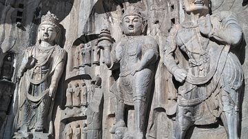
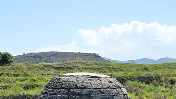
The stupas came to represent the zenith of buddhist architectural achievement in the region and of course, as with the artwork, they are also meant solely to promote the religious power structures. The stupas themselves were decorated with uncountable relief panels and friezes depicting religious stories and events further solidifying their role.
Some of the most prominent stupas include:
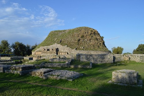
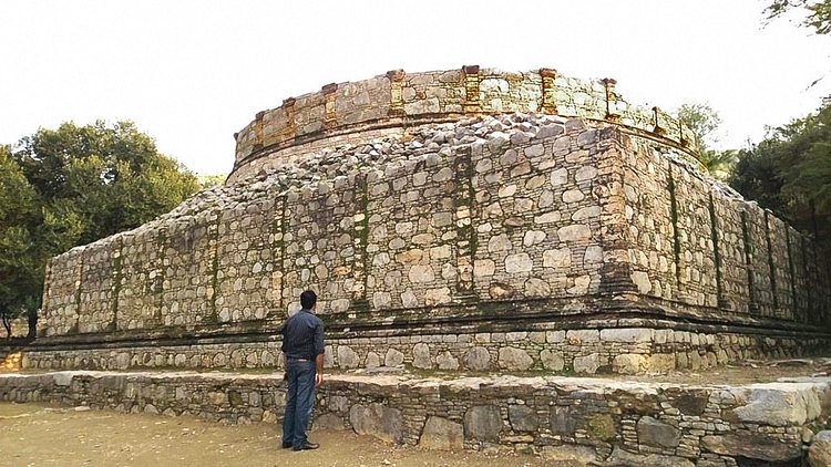
Dharmarajika Stupa
This is the largest Buddhist establishment in the Taxila region and dates from the time of Ashoka, the great Mauryan emperor who united India in the 3rd cent BCE and is known in some Buddhist sources as Dharmaraj, the name which the site itself is associated with.
It is firmly believed by most scholars that Dharmarajika is one of the locations where the remains of the Buddha himself were buried and this makes it a relic depository stupa or Dhatu-Garbha stupa. Ashoka had an afinity to Taxila due to his governership of the area during the time of his father Bindusara and hence also chose this as one of the locations to re-inter the remains of the historical Buddha.
The current site is the second reconstruction over the original Ashokan stupa, the first one occuring in the post earthquake period in the Kushan era (1st Cent CE) and the other much later. The original stupa was presumably smaller and humbler over which the existing dome was established, with radiating support walls like wheel spokes holding up the dome itself. The dome is 45 feet in height inside a 150 ft square having a diameter of approximately 115ft on average, not including the processional path.
Kunala Stupa
The legend associated with this stupa connects it to Kunala, son of Ashoka. Kunala was then governor of Taxila and his step mother lusted for him. He rebutted her advances and in her rage she sent a fake missive by Ashoka to Taxila asking the administrators to blind Kunala. Kunala accepted the punishment even though he was guiltless, and afterwards led the life of a wandering mistrel, singing the story of his misfortune anonymously. He managed to make his way to Ashoka while wandering India, and Ashoka, upon hearing the song knew it to be his son and the story to be the truth and accepted him back, after which Kunala's sight was miraculously restored at Bodh Gaya.
The Stupa at Taxila was established to commemorate that legend although the existing remains cover an older stupa which has not been dated yet. The latest remains are dated to the 3rd-4th Cent CE.
Jaulian Stupa
This 2nd cent CE establishment is a highly decorated and compact construction which is situated in the neighborhood of the city of Sirsukh, rising 300 ft above the Taxila valley and within view of Sirsukh. The name Jaulian means "Seat of Saints" in the local language, a name which has probably existed since antiquity. The Jaulian establishment is a later work and is very lavish, harkening to a time in the Buddhist history of the region when the superficial depiction of the Buddha image was at its peak. It has numerous chapels and votive stupas in its two courts and once housed massive Buddha sculptures as well. Its location is considered one of the most picturesque in the region.
Other sites include the Mohra Moradu complex, Jinna Wali Dheri and the recently re-excavated Bhamala stupa (a rare cruciform stupa).
Each of these establishments has associated monasteries and other auxiliary buildings creating a fairly uniform pattern of planning as with other Gandharan sites.
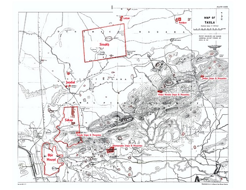
Although today Taxila is known as a "region", in antiquity it was the name of a city which spread over 3 sites dating from the vedic era down to the late ancient period. Known now by place names where the remains were found, the cities in antiquity were probably all known with the same name i.e. Takshasila. These include the archaeological remains today at:
Bhir Mound
The archaeological remains of this, the 1st city, exist south of the existing Taxila Museum covering an area of approximately 1200 x 730 yards rising 65 feet above the Tamra rivulet, the main ancient source of water for the city and consist of 4 levels ranging from the 5th-6th cent BCE (Achaemenid period) to the 2nd cent BCE in the Indo/Bactrian Greek period.
Earlier excavations before the 1970s CE had revealed an organic layout without any evidence of fortifications. The masonry ranges from early rubble masonry in the earliest periods to more consistent masonry later on beginning in what is considered the Mauryan era (3rd-4th cent BCE). Thick coating of mud plaster is in evidence early on and later converts to lime plaster in the Indo-Greek period. Limestone and Kanjur stone are used for construction here.
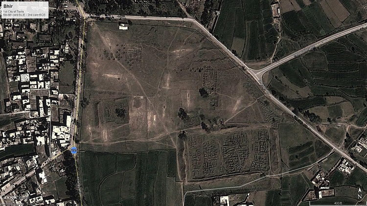
The eastern excavations reveal dwelling houses and shops divided by streets and lanes. There is one mostly straight main street called First Street with other more meandering streets around it. The houses follow largely the same pattern of design and layout as rural houses of today do with a large open courtyard bound by rooms. The outer rooms faced the street and probably served as shops run by homeowners as evidenced by craft materials found from these rooms.
There is evidence of sophisticated drainage for both household water runoff as well as soak wells for sewage.
The most significant building is the Pillared Hall dating from 250-175 BCE, consisting of multiple spaces built over time. Terracotta reliefs and figurines depicting deities were found near this site leading to speculation that it would have been a religious shrine or temple, perhaps even one of the earliest Hindu shrines.
Excavations conducted from 1998-2000 CE by the Federal Archaeological Department of Pakistan unveiled regular town planning, wells and the city's encircling mud and wood rampart which had not been discovered before. These excavations were in the western portion of the site.
We can tell that Bhir predates Gandhara proper due to no Gandhara sculptures being found there yet and the topmost levels revealing only early Indo-Greek coinage with clear Hellenistic influences as well as early Indian punch-marked and bent bar coins. Other finds include beads, seals, terracotta figures and ritual objects all exhibited at Taxila Museum.
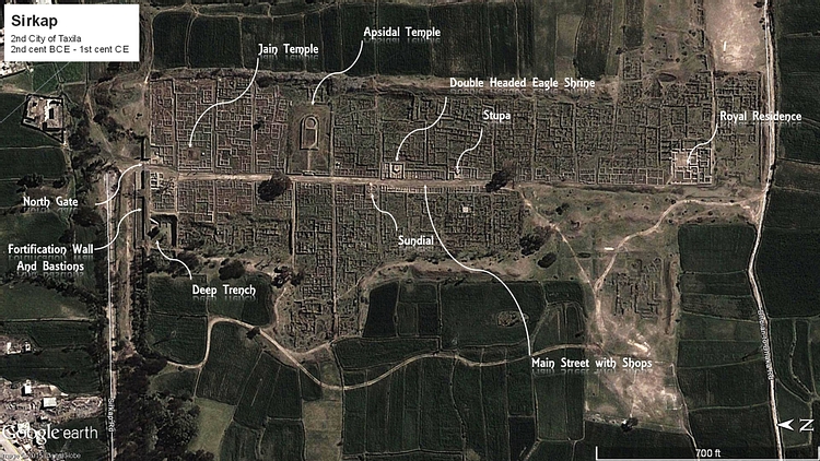
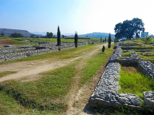
Sirkap
The 2nd ancient city of Sirkap is thought to have been formally established by the Bactrian Greeks in the 2nd cent BCE. The name of the city is associated with a local legend of the hero Rasalu who fought the seven demon Rakhshasas. These were 7 sibling demons namely 3 brothers named Sirkap, Sirsukh and Amba, and 4 sisters named Kapi, Kalpi, Munda and Mandehi. Rasalu was the son of the Raja of Sakala (modern Sialkot) and on coming to the city he found that the demons were demanding sacrifices from the locals. He took it upon himself to kill the demons, vanquishing all but one which is said to still be in hiding. The city marks the spot where he killed the demon Sirkap.
The city has been attributed to the Greeks not only because of the archaeological remains but also because of various urban planning factors such as the flat ground, Hippodamian street pattern and geographical location with natural defences on all sides as well as the upper and lower cities (of which the lower is excavated) although these were also present in the earlier Indus cities. Nonetheless no buildings culturally related to the Greeks have been found such as temples, palaces or theatres which have cultural links to the Greek heritage. After the original planning was implemented, the subsequent settlement was quintissentially Indian.
The fortifications are massive with huge stone walls ranging 15ft to 21ft in thickness, with triple storey bastions at intervals. The fortifications run 6000 yards or 3 miles around the city and traverse the hills to the South as well.
7 occupation levels have been identified with the lowest one (7th) belonging to pre-Greek era and representing an outlying setlement of Bhir and the earliest one (1st) dating from the Scytho-Parthian era, a period of approximately 150 years (~90 BCE to ~60 CE) which saw conquests by the Scythians and then the Parthians in quick succession. Some areas of importance include the Royal Residence, Sun Temple, Apsidal Temple, Double Headed Eagle Stupa and the Jain Temple
Sirsukh
Founded in the 2nd half of the 1st cent CE, the Kushan city of Sirsukh was probably established either to shift the populace away from the earthquake ruined remains of Sirkap, or to establish a new capital to testify to the Kushan conquest.
It is a roughly rectangular city which is in the open plain with no natural defenses but with solidly built limestone fortifications having round towers at regular intervals, one of the first instances of round fortifications outside of the European continent. This was probably adopted by the Kushans during their interaction with Europe on their western borders.
Although an important part of the archaeological landscape, the site has not been properly excavated due to local farming in the area which would need to be heavily disrupted in order to facilitate the excavations. However the narrow strip of fortifications around the Lundi rivulet which hugs the walls on one side have revealed coin hoards of not just the Kushan rulers but also dating to the time of the Mughal emperor Akbar, showing that the city continued to function at least 1000 years after its original foundation.
Decline of the Metropolis
Although the general view has been that the White Huns or Hephthalites were the cause of destruction in Gandhara, subsequent evidence has shown this to not be the whole case. During the time when the White Huns were gaining ascendency, there was a revival in the Brahamanic religion in India proper and Vishnu and Shivaite cults were gaining prominence. This was seen as a resurgence of the old faith as a response to the 1000-year dominance of Buddhism in the region, a religion that had become a shadow of its former self, with the decadence and opulence of the monasteries and stupas overtaking its original message.
At this time Buddhism had traveled far north into China and in India itself the strength of Hinduism was waining. The incoming White Hun rulers, although perhaps not physically disruptive to the region, were nonetheless religiously inclined towards Shivaism, and it is for this reason that their patronage of Buddhism in Gandhara was nonexistent. Since the entire character of this region was based around the unifying element of Buddhism and monastic life, an almost sudden decrease in royal patronage led to the vast and opulent monasteries with their scores of students and monks being unable to sustain themselves. The urban nature of Taxila declined as the unifying religion became less and less stable and eventually, not due to force but due to a simple lack of resources, the monastic complexes of Taxila along with the urban life they generated, fell into disrepair and decay, as mentioned by XuanXang in his chronicles dating from the 7th century CE.
Nonetheless even though the Urban life vanished, the rural life of the region continued even up to Mughal times, with the nearby Margala pass continuing to serve (to this day) an important route from East to West as it did in antiquity.
Although the physical remains of Gandhara disappeared from Taxila as their lifeblood was sapped away, its geographical nature continued to keep it occupied in parts, with the name being converted to the modern Margala (via Persian language during the Mughal era) and the urban pattern being replaced by the fortified hill outposts which dot the landscape today. Indeed even the current place names such as Jaulian (Seat of Saints) and Bhir-Dargahi (from "Pir" or saint meaning 'Sacred home of the Saint') show that its religious nature continued to shift even as the entire cultural landscape changed. Indeed even today there are shrines of Muslim saints in close proximity to or in some cases (like Mohra Moradu) right within the older monastic establishments. This shows that while the outward signs of Taxila as a center of Gandhara civilization did indeed vanish, the soul of Taxila as a spiritual center lived on, adapting itself to a new paradigm.